My dear hosts, distinguished map historians, ladies and gentlemen. My time being so confined, I will dispense with the courtesies of saying what a delight and honour it is for me to be invited at this 24th International Conference on the History of Cartography in this most famous library, the Российская государственная библиотека (Russian State Library, Moscow). So I want to come straight into the subject of my presentation: the analysis of maps of the Warsaw Ghetto. |
||
(2) I start with some modern maps. This basic digital map is from The Teachers Guide to the Holocaust. This Map of the Warsaw Ghetto dominates the internet and is copied many thousand times. Unfortunately, the map is quite incorrect and misleading: it suggests that the ghetto walls follow the streets, which is only partially correct. The Great Tlomackie Synagogue (number 4) lies outside the ghetto, while in fact it started inside. There is no indication of the Umschlagplatz, the railway station so central for the mass deportations to Treblinka. The map gives no date and therefore suggests that it represents its entire history from November 1940 until May 1943. The area depicted on the map is a third larger than the ghetto ever was on the ground, etcetera. Of course all basic maps are limited and simplifying, though they need not be incorrect. A fine example of correct educational maps of this ghetto are on the website of the U.S. Holocaust Memorial Museum.
|
||
(3) At the other side of the spectrum we have very detailed maps of the Warsaw Ghetto, like this one with the Borders before the great liquidation action in the summer of 1942. This map allows us to trace and date the exclusions from the ghetto (in light blue) and the inclusions in it (in light green) of particular area’s, sections of streets and blocks of houses. This is one of the 8 maps, carefully drawn by Pawel Weszpinski, which form an integral part of the 900 pages book by Barbara Engelking and Jacek Leociak: The Warsaw Ghetto, a Guide to the Perished City (2009). The basis for these modern maps of the ghetto comes from cadastral and other pre-war maps of Warsaw. My only problem is that they don’t indicate the heavy destructions caused by bombardments and fires during the German assault on the city; though there still exists a detailed German map of Warsaw on this topic from early 1940. There are three other chronological maps: one with the Residual ghetto after the great liquidation action, one map on The Warsaw Ghetto Uprising in April/May 1943 and one map with the Structure of Streets and Remains of Buildings in March 2001. Moreover the book presents four maps on key themes of daily life in the ghetto: there is a map on Communication, one on Offices, Health Care, Children and Education, one on Trade, Services and Production, and one on Social Life. Together they form a modern atlas of the Warsaw ghetto, a cartographic reconstruction that is unprecedented in scale, method and precision. So what more could I say about maps of the ghetto, after this masterful Guide ? |
||
There remains however one question that is central in my work as a historian and map curator. When I study the history of maps I am as much interested in the ways how maps are used as in how they were made. But research on how maps shape history lags far behind the research in the history of cartography. So today, when I analyse maps of the Warsaw ghetto, my question is: to what extent are plans and maps instrumental to the organisation of terror and of resistance? Sources for dealing with this question are not abundant. Most of the official texts about changing plans and personal memoirs on how they were perceived and acted upon are cited in the Guide of Engelking and Leociak. Moreover, there are several original wartime maps that have survived. Most of these are in my private collection, of others I have scans in different qualities. |
||
(4) Now you see part of the legenda of a secret map of Warsaw. Special symbols in red and purple indicate barracks and weapon depots, airfields and radio transmitters, factories and government buildings, post offices and paper mills, backeries, butchers and breweries, railway stations and hospitals. |
||
(5) This map in the scale of 1 to 20.000 is made by the General Staf of the German Army. Its department for military geography, also called the Topographietruppe, produced all kinds of war maps by revising local maps on the basis of aerial photographs and information gathered by spies. Together with target pictures this map was essential for preparing the air-raids of september 1939. The heaviest bombardement of Warsaw wrought especially havoc in the old Jewish neighbourhood. That was on September 25; in the Jewish calendar this is Yom Kippur, the Day of Atonement. |
||
Rarely studied is the role that plans for a ghetto play in creating a climate of fear in occupied Warsaw in 1939/40. I will follow some of them. Saturday (!) the 4th of November 1939 the SS calls for an extraordinary session of the recently installed Jewish Council and orders the Jews to concentrate in the old Jewish district within three days. They bring several maps with different boundaries of the planned ghetto drawn in. Their intention to set up a ghetto for Jews spreads like wildfire and causes panic. A chronicler notes: Families scattered throughout the entire town, who have assimilated into the Polish population, are ordered to move to Jewish neighbourhoods, to a community with which they often no longer have anything in common. After long days of negotiations between Chairman Czerniaków of the Jewish Council and the Military Commander of the city the Germans give up their plan, giving the impression that it is possible to come to terms with them. But on November the 30th it becomes compulsory for all Jews over twelve to wear an armband with the star of David. The term Jew is used in the definition of the Nuremberg Laws, covering also converts to Christianity and those who are only partially of ‘Jewish blood’. |
||
(6) Already on October 5, 1939, when Hitler in Warsaw takes the salute of a triumphant parade, the central Jewish neighbourhood was a no-go area. This simple map in a photobook from end 1939 with the parade route of the German troops shows the Jewish district. Five months later, March 1940, the Jewish Council is ordered to fence off streets around this district because it is an area threatened by epidemics (Seuchensperrgebiet). The teacher Chaim Kaplan writes in his diary: They treat Jews like lepers. The construction of fences coincides with anti-Jewish excesses in Warsaw. In the same week shops are plundered, apartments looted, traditional looking Jews beaten up and anti-semitic slogans shouted. These excesses are inspired by Germans but carried out by Polish hooligans. This brings the desired propaganda effects: the Poles are compromised and the Germans can be represented as defenders of the Jews. We have here a dual image: the Jews threaten non-Jews because they are bearers of infection and at the same time the Jews are threatened. Both claims come down to the same measure; to wall in their district. |
||
(7) In April 1940 a plan for two ghetto’s is put forward: one in the West covering the area of Wola and Kolo, the other in the East covering Grochów. It is assumed that ghetto’s on the outskirts cause minimal damage to the economy and communication. But when the Führer considers sending millions of European Jews after the war in the West to the French colony of Madagascar, the plan is postponed until August. By then the Department of Resettlement in Warsaw claims that relocating 600.000 people, Jews and Poles, will require at least four months. But creating a ghetto in the old Jewish district can be completed before the winter, when epidemics will spread. The decision to designate this area as a ghetto provokes new fears among Jews but also some hopes of postponing its realisation or at least avoid the worst: a sealed ghetto. Kaplan’s diary reads: It is hard to live in a time when you are not sure of tomorrow, and there is no greater torture than waiting. It is the torture of those condemned to die. |
||
Then October 12 1940, again Yom Kippur, a decree on setting up three housing districts - German, Polish and Jewish - makes the ghetto inevitable. On October 15 the German controlled Gazeta Zydowska and Nowy Kurier Warszawski publish this new plan (8). All Jews of Warsaw living outside this area have to move within a few weeks to the ghetto which takes in some of the poorest and most crowded parts of the city. I’m sure you recognize the plan (9). Its outlines are the same as in the Teachers Guide to the Holocaust. But how did it get there? I found the missing link: this map (10) in the Black Book of Polish Jewry from New York 1943. The newspaper map is indeed the first public map of a ghetto in Warsaw. And while families living elsewhere start feverishly to sell their property and look for some room inside this ghetto, the quarrel about its exact borders becomes very intense. Already the next day the newspapers point out that the boundary streets are to be inhabited on both sides by an Aryan population. Jews are to move out of them. This means that most of the closing walls of the gettho will have to go through backyards. And this is not the last alteration. On the contrary, the chaos is getting worse. On October 22 Kaplan notes: The Polish side began to haggle - in this neighbourhood they have a church; another is mainly inhabited by Aryans; ... there is a factory employing thousands of Aryan workers… Thus they excised .. street after street, of the Jewish area, and the boundaries of the ghetto grew more and more constricted. This proces of continual adjustments of boundaries is the reason why thousands of families have to move several times. We see also how the nazis succeed in framing their racial terms as this diary fragment speaks about the bickering between Aryans and Jews instead of between Jewish Poles and Catholic Poles. |
|
|
After a month of conflicts the Nowy Kurier Warszawski publishes November 14 a new detailed plan of the boundary of the Jewish district. (11) I have here the map on which this plan is based. You recognise the secret map of Warsaw that is used as background for the handdrawn boundaries of the Judenghetto. This manuscript plan is by SS-Sturmbannführer Jesuiter, chief of staff of the Warsaw SS. In the picture you see Max Jesuiter in the center. |
||
(12) November 16 the ghetto is completely sealed off. People can only leave with special passes. The gates of the ghetto are guarded by German gendarmerie, by Polish police and from the inside by Jewish police. Kaplan writes: We went to bed in the Jewish quarter, and the next day we awoke in a closed Jewish ghetto. I have colored on the map from the Teachers Guide the large reductions in red and the few small extensions in yellow (13), just for the one month from the first public plan to the start of the ghetto. Even at the very last moment there is a new development. Nowy Kurier Warszawski for 16/17 November lists in detail the boundaries of the ghetto, specifying the streets and the numbers of the houses besides which the border runs. An innovation compared to the Jesuiter plan is the designation of a small enclave. |
||
This enclave with an Evangelical hospital and a Reformed church is shown on this public city map from early 1941 (14). The irregular shape of the ghetto is the result of pressures by Polish leading figures on the German authorities. They advocate the interests of Christians against the proposals of the Jewish Council. With the resettlement of 113.000 Christian Poles against 138.000 Jews the proces of shaping identities of ‘Jews versus Poles’ takes a grim turn. |
||
(15) You see now this public map of Warsaw in German and Polish from early 1941 in its entirety and also a secret German military map from early 1942. In the period in between constant changes continue to provoke fear. To compare both maps I zoom in on the ghetto and emphasize the borders on the first map. |
||
(16) I analyse only a few differences. From January to March 50.000 Jews living west of Warsaw have to join the already very crowded ghetto. In the same months the Germans attempt to exclude a part where many well-to-do Jewish families live: Sienna Street and Wielka Street in the South and the South East of the ghetto. But in Sienna Street a ‘select committee’ collects money and buys 3 kilos of gold, which they present through a middleman to the German authorities. Bribes like this remove the planned exclusion, but only for half a year. It is generally believed that German ánd Jewish officials are bribeable. On a caricature map that circulates in the ghetto, jukeboxes are drawn in office places, the various dimensions of these jukeboxes are suppose to correspond to their degree of corruption. In the year between these maps 10 % of the 440.000 Jews in the ghetto die. There still are some restaurants and nightclubs, with music and wines for the rich and the corrupt but in many places people are dying from typhoid, hunger and cold. The ghetto is reduced even faster than its death rate. November 28, Nowy Kurier Warszawski brings the news: Jews Vandalized an Apartment in Revenge for Being Forced to Leave It. Some weeks later this framing is mirrored hundredfold. The historian Emmanuel Ringelblum, the head of the secret archive group Oneg Shabbat (Joy of Sabbath), records that after the forced secession of 4 large areas from the ghetto, the Jews get some small blocks at its western border in return, on Wolnosc, Chlodna and Zelazna streets: The Christians left their appartments in a terrible state. They’ve taken the windows, locks, door frames, even floors and gas meters. They completely demolish them. In this year the gates are reduced in number, from 22 to 9, making communication even more difficult. To survive there is one dangerous but very profitable activity: smuggling. Almost more food arrives in the ghetto by smuggling than by legal methods. Children are the heroes among the individual smugglers. They manage to squeeze their little bodies through holes under the walls. Special pockets sown inside their coats carry potatoes, onions or other goods. Often the survival of whole families depends on their courage and cunning. But in October the Nazis issue the death penalty for the unauthorized leaving of the ghetto and the same penalty on Aryans sheltering Jews. The new boundaries intend also to reduce the smuggling. They move from often invisible walls in backyards and adjoining cellars into guarded streets. Chances of getting caught become now much greater and most guards don't hesitate to beat up or even to shoot children. A passage I read, on a ten year old smuggler, keeps haunting my memory. When the German guard got hold of him, the man lifted a sewer hatch and simply dropped the boy into it. |
||
(17) On the map from beginning 1942 you see that the ghetto is now divided into a small and a larger part. On January 26 a wooden footbridge is opened over Chlodna Street to connect the two. Its 52 steps at either side become a heavy burden for people already suffering from malnutrition. Guards hit slow pedestrians to speed up; especially here the topography of the ghetto enters the body. The footbridge is called Bridge of Sighs for another reason as well. The Jews can get a nice panorama of Warsaw on top of the bridge. A view of a world that exists almost at arms length, but remains inaccessible. |
||
(18) I will be very brief on the Great Deportation and the Ghetto Uprising, since they are well known. July 22 1942, on the eve of the commemoration of the destruction of the First and Second Temple in Jerusalem, the Great Deportation begins. The Germans use lists of Jews and maps of their residences provided by the Jewish Council. The deportees are held in check by SS led units, assisted by Jewish Police. The same day the liquidation of the small ghetto starts. The internal resettlement is also meant to distract the attention from the raging deportations. Many Jews still hope that through production work for the German Army the majority will be able to survive in Warsaw. But the employment certificates gradually lose their value. Two months later, on September 21, again Yom Kippur, the last transport departs from the railway station, the Umschlagplatz. In the meantime almost 300.000 Jews have been deported. On this reconstruction map from Engelking and Leociak’s Guide the red and yellow dotted lines indicate the borders of the residual ghetto in autumn ’42. In these areas of the big German factories 35.000 Jews work legally while some 25.000 remain illegally. The pinkish colored areas of the former ghetto are included in the ‘Aryan’ part of the city. The blue parts are uninhabited ‘wild’ areas, though many Jews remain there hidden in attics and cellars. |
||
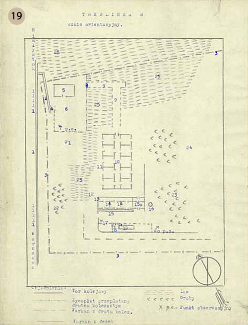
(19) The deportees are told they will be taken to camps in the east where there is a shortage of agricultural laborers. But railway men inform the Jewish underground that the train wagons are back at the Umschlagplatz within days. In September an escapee from Treblinka, Jakub Abraham Krzepicki, returns to the ghetto and reports what goes on in this camp. This simple manuscript map in Polish, drawn in indelible ink with typed explanations, is based on his observations. It is preserved in the Ringelblum Archive of the Jewish Historical Institute in Warsaw. You see a sketch of the extermination camp with the train tracks to the left. Number 9 is the ‘tube’ to ‘the shower building’ (number 10) where the Jews are gassed. Their bodies are burned on open-air grids and the remains thrown in mass graves. In larger Treblinka there are barracks for Jewish forced labourers, for Ukrainian guards and for German overseers. In Warsaw, people like Ringelblum had already in Februari 1942 reached the conclusion that the new policy of the nazis is to kill the Jews of Europe. But most people could not believe this. Ringelblum reflects in december: Initially people did not believe at all in Treblinka, and anyone who spoke about it was shouted down as a spreader of panic. ... It was not understood that is was possible simply to murder tens of thousands of innocent men, women and children. Maps like this one by Oneg Shabbat are not only made for the prosecution when time would come to bring the nazis to justice. This simple map functions foremost as a means to locate the unimaginable. Even for people who know many facts it is not easy to admit that they are in the midst of a genocide. There is one decent alternative: to die fighting. |
||
(20) The largest Jewish Fighting Organization (the Zydowska Organizacja Bojowa) is formed in the summer by members of Jewish youth organizations, who call for the Jews to resist deportation. However, the ZOB is not yet ready to stage a revolt. In October they incorporate members of zionist and socialist organizations and establish contact with the Polish underground. Mordechai Anielewicz is appointed as commander. When the deportations resume in January 1943 the first armed Jewish resistance breaks out which, after four days, brings them to a halt. In March Anielewicz requests more arms from the Polish Underground Home Army: I am prepared to submit within two days accurate plans of our positions, with maps, so that there need be no doubt whatsoever concerning the necessity of the supply. The Home Army, realising that an uprising can only succeed when it is actively supported by the Allies, provides a small number of weapons and escape maps through the sewer system. Some of their groups fear that the arms will go to Jews who sympathise with the Soviets. On April 19, the eve of Pesach, the Germans return to liquidate the remaining ghetto; now the heroic uprising breaks out. I have only this reconstruction map from the Guide. Here you see insurgents bunkers and places of the greatest fights and also red arrows of small but brave Polish actions of armed help. In the meantime German special forces start burning the ghetto, building by building, to force the Jews out of their hiding places. Nevertheless the Jewish guerilla continues for weeks. |
||
(21) On May 8 the bunker of the ZOB command at 18 Mila Street is uncovered, the main entrance is forced, and canisters of poison gas are thrown in. Some fighters, like Anielewicz, take their own lives rather than surrender, while others perish from the gas. A handful succeed in taking shelter in an alcove and later escape via the sewers. Here you see a map of Warsaw from 1936 with its sewer system, recently published online by the Wojskowy Instytut Geograficzny. Not many Jews can leave the burning ghetto through this labyrinth, which in many parts is only 70 cm high. Marek Edelman recalls how a paid sewage worker guides him and 40 other Jews: In the sewers we constantly came across wire entanglements made by the all-forseeing Germans. The manholes were covered with rubble. ... Every now and then the Germans dropped in poison gas. Still 30 persons of this group manage to get out. May 16 the Germans blow up the Great Synagogue in Tlomaskie Street as a sign that the uprising is finally crushed. |
||
(22) I conclude this presentation with the first history map of the Warsaw ghetto, which appeared in Geneva 1944 in this study of dr. Silberschein. The greatest burden of the ghetto was that its Jews felt abandoned by other Poles, by the Allied Forces and even by God. Today the area is almost deprived of physical traces from the ghetto. A modern reality is build in its place with several monuments to commemorate its fate. The ghetto that was there is gone forever but, as Leociak indicates, this ‘there’ remains as a painful topographical abstraction. |
||
© Harrie Teunissen From Mauritsstad to New Amsterdam: Mapping Early Jewish Presence in the Americas The Holocaust in Contemporary Maps Lebensraum und Getto. Karten der Warthegau, Pläne von Litzmanstadt
Harrie Teunissen and his partner John Steegh are map-collectors from Leiden in Holland. Their jointly build up collection of some 8000 maps and 1200 atlasses and travel guides, mostly from 1750 – 1950, focuses on water management, city development, ethnic relations and military conflicts. They organise exhibitions based on this collection, like ‘The Balkan in maps, five centuries of struggle about identity’ (Leiden University Library 2003). This presentation forms part of Teunissen's project 'Mapping Jewish History'.
A Select Bibliography New York 1974 |
||